Key Takeaways
- Tornadoes and hurricanes are both powerful atmospheric phenomena but differ significantly in scale, formation, and impact.
- Tornadoes are localized, short-lived vortices, while hurricanes are massive cyclonic systems spanning hundreds of miles.
- The damage patterns and warning times for tornadoes and hurricanes vary greatly due to their distinct characteristics.
- Each phenomenon affects geopolitical boundaries differently, influencing disaster management and regional planning.
- Understanding these differences is crucial for tailoring effective emergency responses in affected regions.
What is Tornado?

Table of Contents
A tornado is a rapidly rotating column of air extending from a thunderstorm to the ground, known for its intense and localized destruction. These phenomena typically occur over land and are characterized by their funnel-shaped appearance.
Formation and Atmospheric Conditions
Tornadoes form when warm, moist air collides with cooler, drier air, creating instability in the atmosphere. This interaction often occurs along weather fronts, especially within supercell thunderstorms, which provide the necessary rotation and updraft.
The role of wind shear is crucial, as it changes wind speed and direction at different altitudes, causing the air to spin horizontally before tilting vertically. This vertical rotation is what eventually funnels downward to form a tornado.
Areas such as the central United States, commonly called “Tornado Alley,” are particularly prone due to their unique geographic and climatic conditions that favor these interactions.
Characteristics and Behavior
Tornadoes vary dramatically in size, shape, and intensity, with wind speeds ranging from 65 to over 300 miles per hour. Their paths are typically narrow, often less than a mile wide, but can extend several miles in length.
Most tornadoes last for only a few minutes, although some rare events can persist much longer, causing extensive damage in their trajectories. Their unpredictable nature makes forecasting challenging, often giving residents only minutes of warning time.
Visual indicators such as rotating debris clouds and changing sky colors often precede tornado formation, but these signs are not always reliable for early detection.
Impact on Geopolitical Boundaries
Tornadoes frequently impact rural and urban areas within defined state or national borders, prompting localized emergency responses. For instance, the 2011 Joplin tornado in Missouri caused widespread devastation within city limits, requiring state-level disaster management coordination.
Because tornadoes can cross county or state lines quickly, inter-jurisdictional cooperation is vital for effective rescue and recovery efforts. This has influenced the development of regional disaster response frameworks in tornado-prone zones.
The economic toll of tornadoes is often concentrated but severe, affecting infrastructure, housing, and local economies, necessitating targeted rebuilding efforts within affected geopolitical boundaries.
Detection and Warning Systems
Advanced Doppler radar systems have improved tornado detection by identifying rotational patterns within thunderstorms. Despite this, the rapid development of tornadoes limits lead times, typically providing residents with only 10 to 15 minutes of warning.
Community-based alert systems, including sirens and mobile notifications, play a crucial role in disseminating warnings to populations at risk. These systems must be tailored to local governance structures to ensure timely and coordinated messaging.
Continuous research into atmospheric modeling aims to enhance prediction accuracy and extend warning periods, improving preparedness at the municipal and state levels.
What is Hurricane?
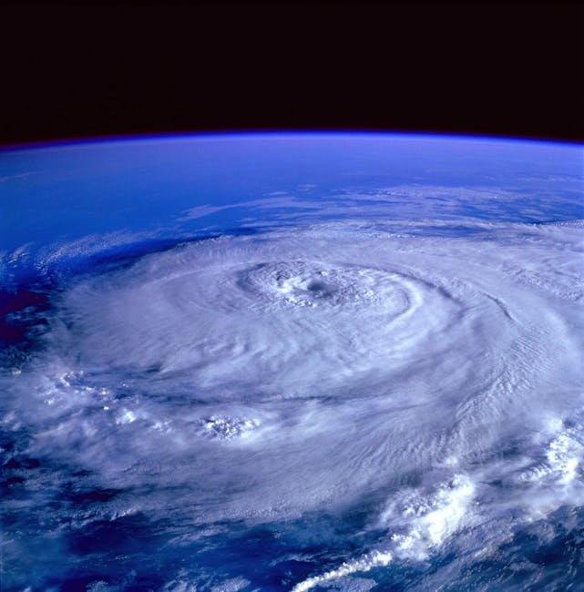
A hurricane is a large-scale tropical cyclone characterized by sustained wind speeds exceeding 74 miles per hour, forming over warm ocean waters. These storms can span hundreds of miles and last for days or weeks, often causing widespread destruction upon landfall.
Formation and Oceanic Influence
Hurricanes develop when ocean surface temperatures rise above approximately 80°F, providing the heat energy necessary to fuel the storm. Warm, moist air rises from the ocean surface, creating low pressure that draws in surrounding air and initiates cyclonic circulation.
The Coriolis effect, caused by Earth’s rotation, deflects the air flow, leading to the characteristic spinning motion of hurricanes. This effect prevents hurricanes from forming near the equator, where the Coriolis force is minimal.
Regions such as the Atlantic Basin and the Gulf of Mexico frequently witness hurricane formation, with geopolitical boundaries like U.S. coastal states and Caribbean nations often in the path of these storms.
Structure and Lifecycle
A hurricane consists of an eye, eyewall, and rainbands that together create a highly organized weather system. The eye is a calm center, surrounded by the eyewall where the strongest winds and heaviest rains occur, causing the greatest damage.
Hurricanes typically progress through stages: tropical depression, tropical storm, and then hurricane, with intensities classified into categories based on wind speed. This lifecycle can span over a week, providing more advanced warning compared to tornadoes.
After making landfall, hurricanes weaken rapidly but can continue causing flooding and wind damage far inland, affecting multiple states or countries across geopolitical boundaries.
Socioeconomic and Political Impacts
Hurricanes impose significant challenges on coastal and island communities, often necessitating large-scale evacuations and federal disaster declarations. The widespread nature of their impact often triggers extensive intergovernmental cooperation, including international aid in some cases.
Economic consequences include damage to critical infrastructure such as ports, oil refineries, and transportation networks, which can disrupt regional and national economies. Political pressure frequently mounts on governments to improve preparedness and resilience in hurricane-prone regions.
Long-term recovery efforts can span years, influencing urban planning, insurance policies, and environmental regulations within affected geopolitical areas.
Forecasting and Preparedness Measures
Satellite technology and numerical weather prediction models enable meteorologists to track hurricane formation, movement, and intensity with considerable lead time. These forecasts allow for organized evacuations and pre-positioning of emergency resources across multiple jurisdictions.
Governments often coordinate multi-agency responses, including military support and humanitarian aid, reflecting the complex nature of hurricane impacts. Public education campaigns emphasize preparedness steps such as securing property and assembling emergency kits.
Improvements in communication infrastructure have enhanced the dissemination of warnings, reducing casualties and enabling faster recovery in hurricane-affected regions.
Comparison Table
The following table highlights key aspects that distinguish tornadoes and hurricanes in terms of their physical characteristics, behavior, and impact on geopolitical boundaries.
| Parameter of Comparison | Tornado | Hurricane |
|---|---|---|
| Typical Diameter | Several hundred meters to about 2 kilometers | Up to 600 kilometers or more |
| Duration | Minutes to an hour | Days to over a week |
| Geographic Origin | Form over land, usually within thunderstorms | Develop over warm tropical ocean waters |
| Wind Speed Range | 65 to over 300 mph | 74 to over 157 mph (Category 1 to 5) |
| Warning Lead Time | Typically 10-15 minutes | Several days |
| Impact Area | Narrow paths, localized destruction | Wide regional impact across multiple states or countries |
| Movement Speed | Variable, often slow and erratic | Generally moves steadily along predictable paths |
| Damage Type | Intense wind damage, debris, localized flooding | Wind damage, storm surge, widespread flooding |
| Emergency Response Scale | Primarily local and state level | Local, state, national, and international coordination |
| Common Affected Regions |